|
Many experts believe that the loop
current which never comes closer than about 100 miles from the
majority of Florida's west coast, will funnel the oil south of the
Keys. State officials are more concerned about the potential threat
to south and east Florida and not the west coast.
JULY 2 - Government forecasters say there's up to an 80 percent
chance that the massive oil spill will reach the waters off Miami by
the middle of August, caught in the loop current around Florida and
then pushed northward up the state's east coast at a rate of 100
miles per day. The oil would bypass Florida's west coast, but it
would thread through the delicate environment of the Florida Keys
before moving toward Miami and Ft. Lauderdale. Most forecasts
anticipate that Louisiana will continue to be besieged by the oil,
though Texas will be spared.
June 15 - The University of Miami is announcing that a research
cruise sponsored by the National Science Foundation has discovered
that a large oil plume originating from the Deepwater Horizon site
is heading for the Dry Tortugas. These islands, preserved as part of
a US national park, reside just to the west of the Florida Keys.
Should the oil make it that far, it will almost certainly find its
way into the Atlantic Ocean.
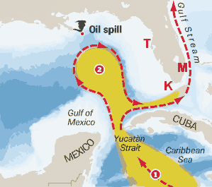
The flow of the oil from the Deepwater Horizon has been difficult to
track, since the source is on the sea floor, while oil's buoyancy
will cause it to move towards the surface. On its way there, it will
encounter different currents at various depths. The currents in the
Gulf are dominated by what's called the Loop Current, which enters
the Gulf between Cuba and the Yucatan. What happens next can vary
considerably.
Depending on a variety of factors, the Loop can extend well north in
a large clockwise sweep through the Gulf before exiting into the
Atlantic near the Florida Keys. At other points, this loop pinches
off into an independent vortex as the main current heads directly
for the Atlantic. The precise configuration of these currents will
strongly influence the flow of oil as it's released from the well,
and thus help control where the largest environmental impacts will
be.
The University of Florida announced some success in tracking the oil
as it moves away from the source. The school's modeling group made
predictions about the spill's progress that were used to direct a
research vessel on a cruise through the Gulf. That vessel
encountered a large plume of oil that, based on the prevailing
currents, is moving towards the Dry Tortugas. Should it get that
far, the oil will almost certainly spread through the Keys and up
the east coast of Florida, carried that way by the Florida current.
Tracking the spread of the oil is only part of the challenge, as
we'll ultimately need to know how much oil has been released in
order to prepare mitigation and recovery efforts. Right now, we seem
to be nowhere close to having a grip on that.
The clockwise flow that extends northward into the Gulf of Mexico
and joins the Yucatan Current and the Florida Current is known as
the Loop Current
Another Public Service
Report from The Top Team, at Florida's Largest Real Estate Office
- Charles Rutenberg Realty
Back
to Florida Hurricane Weather Main Page |